
Nile River and Ancient Egypt
The Nile River is one of the world's most famous waterways. It spans over 4,132 miles through northeastern Africa. Its importance goes beyond its long length, however. It has served as the heart of Egypt's civilization for 5,000 years and continues to shape the culture and human geography of the region.
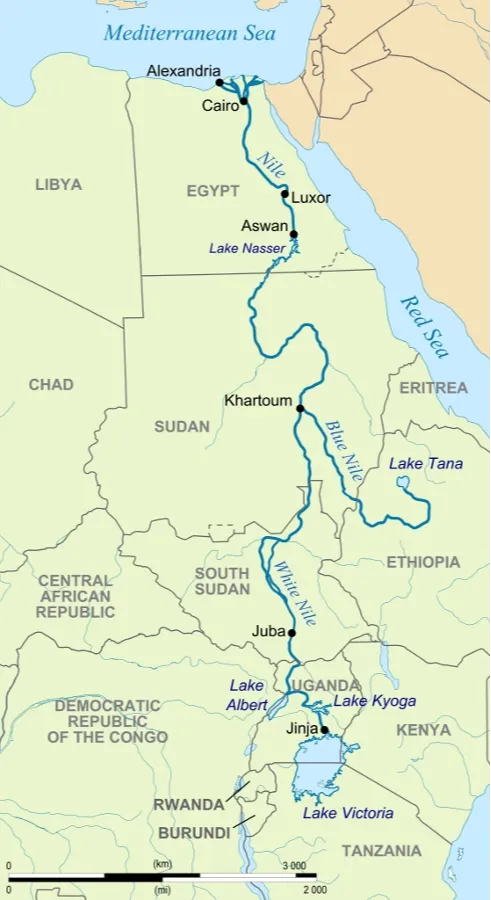
Two main tributaries form the Nile: the White Nile and the Blue Nile. The White Nile begins at Lake No in South Sudan. Its name comes from its pale color due to clay sediment carried in the water. The Blue is the larger of the two tributaries and begins at Lake Tana in Ethiopia. Blue Nile Falls, a 138-foot-tall waterfall is found near the beginning of the river.
The two rivers come together near Khartoum, Sudan before flowing north into Egypt and eventually emptying into the Mediterranean Sea at the Nile Delta. The Nile's annual flooding, caused by seasonal rains in the Ethiopian Highlands, deposit nutrient-rich silt along its banks, creating fertile ground for agriculture.
Ancient Egypt, one of the world's earliest civilizations, emerged along the banks of the Nile around 3100 BCE. The Nile's predictable flooding enabled the Egyptians to develop advanced agricultural techniques, such as irrigation and crop rotation. This allowed for surplus food production and the growth of urban centers.
The Nile also played a central role in Egyptian religion, mythology, and culture. The annual flooding was associated with the god Osiris and was believed to symbolize death and rebirth. Additionally, the Nile provided transportation routes for trade and communication, facilitating the exchange of goods and ideas with neighboring civilizations.
The Nile River has left an indelible mark on Egyptian culture, shaping everything from religious beliefs to artistic expression. The ancient Egyptians worshipped the Nile as a deity and incorporated its imagery into their religious rituals and ceremonies. Temples and monuments dedicated to the Nile god Hapi were built along its banks, underscoring its importance in Egyptian society.
The Nile also served as a source of inspiration for Egyptian art and literature. Paintings, sculptures, and hieroglyphic inscriptions often depicted scenes of river life, agriculture, and mythology, providing valuable insights into ancient Egyptian society and worldview.

The Nile is the main factor for Egypt's settlement patterns and urban development. Ancient cities such as Memphis, Thebes, and Alexandria flourished along its banks and were centers of the civilization.
The fertile Nile Delta and floodplain supports dense populations and agricultural communities, while the river itself provides a vital transportation artery for trade and commerce.
Even today, most of Egypt's population resides in the Nile Valley and Delta, where access to water and arable land remains essential for sustainable livelihoods. Urbanization and industrialization have led to the expansion of cities like Cairo and Alexandria, further consolidating the Nile's role as the economic heartland of Egypt.
The Nile River continues to be a cornerstone of Egypt's economy, supporting agriculture, tourism, and hydroelectric power generation. Agriculture remains a significant sector, with the Nile Delta and Valley producing crops such as rice, wheat, cotton, and sugarcane for domestic consumption and export.
The Nile's cultural and historical significance attracts millions of tourists annually, contributing to Egypt's revenue and employment opportunities. The construction of hydroelectric dams, such as the Aswan High Dam, has enabled Egypt to harness the river's energy potential for electricity generation and irrigation purposes, albeit with environmental and social consequences.